Warning: DOMDocument::load(): Opening and ending tag mismatch: meta line 27 and head in http://feeds.enviroflash.info/rss/realtime/165.xml, line: 28 in /home4/scannor1/public_html/get-aqi-rss.php on line 36
Warning: DOMDocument::load(): attributes construct error in http://feeds.enviroflash.info/rss/realtime/165.xml, line: 33 in /home4/scannor1/public_html/get-aqi-rss.php on line 36
Warning: DOMDocument::load(): Couldn't find end of Start Tag script line 33 in http://feeds.enviroflash.info/rss/realtime/165.xml, line: 33 in /home4/scannor1/public_html/get-aqi-rss.php on line 36
Warning: DOMDocument::load(): StartTag: invalid element name in http://feeds.enviroflash.info/rss/realtime/165.xml, line: 38 in /home4/scannor1/public_html/get-aqi-rss.php on line 36
Warning: DOMDocument::load(): Opening and ending tag mismatch: meta line 25 and html in http://feeds.enviroflash.info/rss/realtime/165.xml, line: 42 in /home4/scannor1/public_html/get-aqi-rss.php on line 36
Warning: Undefined array key 0 in /home4/scannor1/public_html/get-aqi-rss.php on line 47
Warning: Trying to access array offset on value of type null in /home4/scannor1/public_html/get-aqi-rss.php on line 47
Deprecated: preg_match(): Passing null to parameter #2 ($subject) of type string is deprecated in /home4/scannor1/public_html/get-aqi-rss.php on line 47
Warning: Undefined array key 0 in /home4/scannor1/public_html/get-aqi-rss.php on line 53
Warning: Trying to access array offset on value of type null in /home4/scannor1/public_html/get-aqi-rss.php on line 53
Deprecated: preg_match(): Passing null to parameter #2 ($subject) of type string is deprecated in /home4/scannor1/public_html/get-aqi-rss.php on line 53
Warning: Undefined array key 1 in /home4/scannor1/public_html/get-aqi-rss.php on line 60
Deprecated: strip_tags(): Passing null to parameter #1 ($string) of type string is deprecated in /home4/scannor1/public_html/get-aqi-rss.php on line 60
Warning: Undefined array key 2 in /home4/scannor1/public_html/get-aqi-rss.php on line 61
Deprecated: strip_tags(): Passing null to parameter #1 ($string) of type string is deprecated in /home4/scannor1/public_html/get-aqi-rss.php on line 61
Warning: Undefined array key 3 in /home4/scannor1/public_html/get-aqi-rss.php on line 62
Deprecated: strip_tags(): Passing null to parameter #1 ($string) of type string is deprecated in /home4/scannor1/public_html/get-aqi-rss.php on line 62
Warning: Undefined array key 0 in /home4/scannor1/public_html/get-aqi-rss.php on line 65
Warning: Trying to access array offset on value of type null in /home4/scannor1/public_html/get-aqi-rss.php on line 65
Deprecated: preg_match(): Passing null to parameter #2 ($subject) of type string is deprecated in /home4/scannor1/public_html/get-aqi-rss.php on line 65
Warning: Undefined array key 1 in /home4/scannor1/public_html/get-aqi-rss.php on line 66
Deprecated: strip_tags(): Passing null to parameter #1 ($string) of type string is deprecated in /home4/scannor1/public_html/get-aqi-rss.php on line 66
METRIC |
IMPERIAL
Updated:
04/18/2024 @ 1:15pm
(0 sec ago)
Temperature
Current Conditions
Forecast / Storm Prediction
Currently Outside:
44.9°F
---
High Today 48.8°F
12:00 AM
Low Today 43.7°F
10:47 AM
Yest High 69.7°F
2:51 PM
Yest Low 35.6°F
6:07 AM
Sta* High 79.9°F
2016
Sta* Low 24.3°F
2014
* This Station's Records Since 1/2013
Overcast
Wind:
SE
0.3 Gusting to: 0.0 mph
Rain: 0.00 in
Current CBI Fire Danger: 5.8 of 100
This Afternoon Rain Showers Likely
Tonight
Chance Rain Showers then Mostly Cloudy
Friday
Mostly Cloudy
Hi 45°F
Lo 38°F
Hi 56°F
Dew Point
Liquid Precipitation
Wind Speed
Sun/Moon
Current:
33.1°F
Last Hour:
+1.7°F
High 5:03 AM:
33.5°F
Low 9:57 AM:
29.4°F
Record High:
73.6°F on
5/9/2023
Record Low:
-24.9°F on
4/2/2023
Wetbulb:
40.2°F
Today:
0.00 in
Yesterday:
0.00 in
Last 7 Days:
1.19 in
Apr Rain:
3.31 in
Apr to Date Avg:10
2.31 in
Apr to Date Diff from Avg:10
1.00 in
Apr Avg:
9.37 in
Diff from Avg:
6.06 in
Season:1
77.49 in
YTD Avg:11
19.16 in
YTD Diff from Avg:11
58.33 in
Last Rain Time/Date:
15/4/2024
at 12:50 AM
47 rain days in 2024
12 days in April
3 days since last rain
Current:
SE
0.3 mph
1Hr Average:
0.8 mph
Wind Run:
9.83 miles
Wind Gust
Current:
0.0 mph
Today:
11.5 mph 9:20 AM
Month:
26.0 mph
Apr-13
Year:
34.5 mph
Feb-29
Record Gust:
34.5 mph
29/2/2024
Sunlight:
13 hrs 20 min 51 sec of Sunlight Today
Which is 2 min 14 sec longer than yesterday (Noon ?>)(Midnight
Waxing Gibbous
77%
Illuminated
Humidity
Barometer
Current:
63%
Last Hour:
5%
High 5:03 AM:
63%
Low 12:00 AM:
52%
Record High:
100%
11/1/2023
Record Low:
15%
23/3/2021
Current:
30.194 inHg
Last Hour:
Steady
High 1:11 PM:
30.196
Low 3:52 AM:
30.122
Record High:
30.711 inHg
16/2/2022
Record Low:
28.895 inHg
23/12/2022
Heating Degree Days
Snow3
Wind Chill
Air
Today:
10.1
Apr:
349.5
2024 to Date:
3196.2
Cooling Degree Days
2024 to Date:
0.0
Today:
0.00 in
Yesterday:
0.00 in
Apr Snow:
0.00 in
Apr Avg:
0.00 in
Diff from Avg:
0.00 in
Season Total:2
0.00 in
Snow Depth:
0.00 in
0 snow days in April
0 snow days this season.2
Average 1st Snow:
0
Current:
44.9°F
Low 10:46 AM:
40.9°F
Yesterday:
35.6°F
Record:
-28.8°F
4/2/2023
Data Not Available
Density:
1.27 kg/m3
Current UV Index
Current Solar Energy9
0.0
Sunburn in
720 Minutes
Highest:
2:12 PM -1.0
0 W/m2 0% W/m2⇒ SISolar % ⇒ SI
High Today:
2:12 PM -1 W/m2 Record: 1316 W/m2
Almanac
Irrigation Index5
Station All Time Records
Cloud Level
Currently:
Afternoon
YTD Avg Temp:
35.5°F
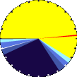
Sunrise:
6:00 am
Sunset:
7:33 pm
Moonrise:
2:29 pm
Moonset:
4:02 am
Full Moon:
23/04/2024
New Moon:
03:23 UTC
07/05/2024
Updated at Midnight
Current ET:
0.00 in
7-Days Rain:
1.19 in
7-Days ET:
0.00 in
7-Day:
1.19 in
April:
3.31 in
HIGHS:
LOWS:
99.0°F
4/8/2022
-14.8°F
4/2/2023
Daytime Records
95.5°F°F 04/08/2022
1.6°F°F 04/02/2023
Nitetime Records
80.4°F°F 25/07/2022
-10.1°F°F 04/02/2023
ICN:18 | S3C2:1 | Ajax 3.xx
ISS:Ok |
1 Rain season: Jan 1st to Dec 31st.
2 Snow season July 1st to June 30th.
3 Snow manually measured usually around 7AM and 7PM.
5 Estimated amount of water needed to replace the water used by plants and evaporation from the past week. (Negative numbers mean amount of water needed, positive numbers mean excess water is present).
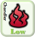
6 Air Quality Index is provided by Minnesota Polution Control Agency and is updated hourly between the hours of 6AM and Midnight.
9 Solar Index represents either an absolute scale of solar energy (W/m²) using the station’s recorded maximum or a percentage of computed theoretical solar maximum using the station’s location and time of day. These indices differ most when the sun is low on the horizon. The current scale is shown, and will toggle if it or the icon is clicked.
10 Historical average only to day 18 of just the month of April for this station since 2013.
11 Historical average rain this season to day 18 of April for this station since 2013.
NWS Weather Forecast -
Outlook This Afternoon & Tonight
This Afternoon Rain Showers Likely
Hi 45°F
NWS forecast: Rain showers likely. Cloudy, with a high near 45. Northeast wind around 10 mph, with gusts as high as 21 mph. Chance of precipitation is 60%. New rainfall amounts less than a tenth of an inch possible.
Tonight
Chance Rain Showers then Mostly Cloudy
Lo 38°F
NWS forecast: A chance of rain showers before 9pm. Mostly cloudy, with a low around 38. Northeast wind 2 to 7 mph. Chance of precipitation is 50%. New rainfall amounts less than a tenth of an inch possible.
NWS Short Term Weather Forecast
Friday
Mostly Cloudy
Friday Night Chance Rain Showers
Saturday
Slight Chance Rain Showers then Partly Sunny
Saturday Night Partly Cloudy
Sunday
Mostly Sunny
Sunday Night Partly Cloudy
Monday
Sunny
Hi 56°F
Lo 43°F
Hi 63°F
Lo 37°F
Hi 59°F
Lo 37°F
Hi 61°F
ajax-dashboard6.php - Version 6.95h - 20-Feb-2023 - Script by: Scott of BurnsvilleWeatherLIVE.com
Now supported by Saratoga-weather.org Download

 Scan With Phone's Bar Code Reader